SpaceWatch.Global An independent perspective on space
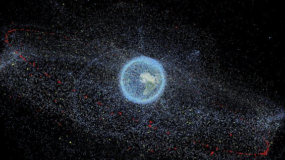
Our planet has a problem… or rather we have created a problem. The Earth’s orbital regimes are becoming increasingly populated with not only satellites but bits of debris of varying sizes: spent rocket stages, nuts, bolts, even fragments of paint and all of these objects pose a threat to operational spacecraft and the space environment. As we talk about the prospect of doing more in space: launching large constellations of small satellite into LEO, asteroid mining, building a Moon village, we need to focus on how we clean up the mess that we have already created. How can we expect to do more in space when we are not cleaning up after ourselves or if we don’t even know what’s up there and what risks it could pose.
Helen Jameson, Editor-in-Chief of SpaceWatch Middle East, was fortunate enough to have an enlightening half-hour chat with Moriba Jah, Associate Professor, Aerospace Engineering and Engineering Mechanics at the University of Texas, Austin, and space environmentalist, who is in the midst of creating a taxonomy that will transform the way we look at the manmade objects that orbit our planet.
Tell us about your background and how you came to be interested in the domain of the space environment.
My studies are in astrodynamics which is the science that studies motion of objects in space. I did my undergrad at Embry-Riddle Aeronautical University in Prescott, Arizona and my graduate work at the University of Colorado at Boulder where I earned my masters and PhD in astrodynamics. I worked for NASA’s Jet Propulsion Laboratory (JPL) for about 7 years as a spacecraft navigator so my job was basically to take in tracking data on specific satellites for Mars missions and to find out where they were and predict where they were going to support a variety of science missions. I then left JPL and worked for the Air Force Research Laboratory for about 10 years and that’s when I started moving away from interplanetary things and more into Earth orbiting objects. That was when I got introduced to space surveillance and tracking and the Space Situational Awareness (SSA) programme. My job within the Air Force Research Laboratory was to use astrodynamics as a basis to try to quantify and understand the population of manmade objects, but very specifically to support decision making processes for the Department of Defense (DoD) related to on orbit threats.
There has been more talk about space situational awareness and the importance of tackling space debris in recent years, but we are still in the same situation despite the best efforts of organisations like the Space Data Association (SDA). How sustainable is the current situation?
There is only one free service that is available at the moment in terms of space situational awareness for orbital safety and that is the service provided by the US DoD. But those products aren’t necessarily the most informative or the most accurate, but they’re free. The DoD finds itself in a very unfortunate situation where it’s been providing these things to the global community but at the same time, because of its mission and purpose, by definition it can’t be fully open and transparent. Certainly, at the UN Committee on Peaceful Uses for Outer Space (COPUOS) that meets in Vienna every year, the US State Department leads the delegation of the United States. On the one hand, the US is talking about transparency and confidence building measures. On the other hand, the operational data that is put out to the world is done so by an organisation that can’t be transparent. This is one of the things that is motivating the US government to find an alternate solution to space traffic management and SSA to support orbital safety. The Federal Aviation Administration (FAA) has been put forth as the body to take this on. To that effect, the FAA has been given the green light to conduct a pilot programme to assess its ability to provide those products to the community.
All of the products that U.S. Strategic Command (USSTRATCOM) makes available are derived products and this means that they are not raw sensor observations. It’s not like they collect telescope data or radar data and make it available to the world. They are not going to do that because they are DoD related sensors, and providing that data to the world could reveal vulnerabilities or sensibilities that could then affect US national security. This is another reason why it needs to be migrated away from the DoD.
The FAA could avail themselves of citizen science (people offering up their own data) to provide that to people to assess. When you are beholden to derived products and you don’t know the math or the processes that went into generating these, then you are susceptible to an unqualified risk and people don’t like that. One of the main hindrances to a really meaningful and global SSA in space traffic management for orbital safety is that you don’t have a lake of observational data that is easily and openly accessible by many people around the globe. If this were available, everyone can do their own algorithm and math and physics to figure out what is contained in the data. When people are able to compare these things, big strides forward are made, and you find yourself in a “data to discovery” environment. The current paradigm doesn’t allow for that so let’s see what the FAA can do in that direction.
The interesting thing that you mention is the Space Data Association (SDA). This is not really like SSA either because it’s a consortium that is a paid-for service and many satellite operators belong to it and provide their own information to the Space Data Centre which is run by Analytical Graphics Incorporated (AGI). The algorithms that are used to process the data are from AGI and guess they’re not openly publicized- the algorithms that AGI uses. Things flow into the black box and things flow out of the black box. Regarding a global space traffic management system, that’s probably not going to work well.
Tell us about the space taxonomy. What is it and how will it work?
I like being able to see what people do to solve problems in other areas and see what commonalities exist so I can pull in ideas from other people. I’m very poor at just making my own math up. I always like to borrow from what other people are doing and use it in what I am trying to solve. Whenever you’re trying to understand how to quantify a population of something, it helps to look at living things. By tagging individuals in a population and then tracking them over time and space, we can observe how those individuals interact with other individuals and in their communities, surroundings and environment. From those interactions, it is then possible to infer things and from that inference, you gain knowledge – you go from data to discovery.
One interesting example of that is when I lived on Maui. There was a period of time when shark attacks were on the rise and the Mayor of Maui County decided to do something about it by assessing the problem so that he could understand where the sharks were that were causing the attacks. They tagged the sharks and tracked them and, over time, mapped where the sharks were at any given point. Here’s one of the examples I use: say that we look at the data, and notice that every Tuesday at lunch, there’s a shark that goes to Makena Beach. So, you send someone to Makena Beach on Tuesday at lunch and lo and behold there is someone in a canoe that is fishing several metres off the shore throwing dead fish into the water to try to attract the bigger fish. All of a sudden you discovery the causation of the identified correlation. This data to discovery process is not currently being done, holistically, to understand things in space.
There is no equivalent of this tag and track and monitoring of how objects interact with other objects and how they interact with the environment to extract holistic inferences about the population and how it’s behaving. There is no scientifically derived, community-standard classification scheme for manmade objects. One of the accepted things is that we have debris, rocket bodies, and payloads. Can three categories really uniquely classify everything in space? Of course not. As long as we treat everything like it’s a sphere – just a dot in space, we are hindered by how much we can understand.
A piece of multi-layered insulation in LEO is going to behave quite differently to a piece of multi-layered insulation in Geostationary Orbit because it’s a different environment, a different “habitat.” We cannot understand that unless we have a classification scheme that is scientifically informed. So, the taxonomy has to be a classification scheme that can explain past observations, it has to be able to uniquely identify objects in space and it has to help us to predict what the behaviour is going to be in the future.
What are the main challenges that you face in terms of making the taxonomy a reality?
Right now there are a couple of projects that I am trying to put together between myself and a couple of small businesses. I have four graduate students that will be working for me and a Post Doctorate Fellow and I have been trying to put together a big global coalition of the willing, and it is very slow. The first thing that must be created is the Data Lake. Without the data lake there is no taxonomy. It cannot be a case of getting some smart people into a room to think this out. It needs to be evidence-based and it needs to come from the data (empirically inferred). The data needs to inform us what that classification scheme is. The motto for my research programme is: if you want to know it, you have to measure it, and if you want to understand it you have to predict it. So any classification scheme that we put together has to comprise of things that are measurable. If they are not measurable, they are not knowable.
We have multiple new constellations set to flood LEO in the next few years. Do you believe that enough concern is being shown by emerging operators to deal with the issues that so many new space objects could cause?
There is a bit of good news. I have been in talks with Planet and they so far have been the most proactive in terms of wanting to be good stewards of the space environment. On their website, if you are a researcher, they say they will give a lot of their data for free about where the satellites are located. They have also said that they are willing to put different hardware on their satellites that will make them more trackable, as long as it doesn’t negatively impact their business model. Planet are definitely spearheading good stewardship of the space environment because they understand that they are operating at an altitude that will be populated more over time so they have been very proactive and I am very proud of what they have been doing.
Along with that, the big constellations that you are talking about are those of OneWeb and SpaceX and I can tell you that I have a call set up to speak to some folks from SpaceX specifically about what can be done to really help with space traffic management.
What are you discovering about the relationship between the behaviour of space objects and geophysical processes? Could what we have put into space over the last 60 years actually be having an effect on what happens to Earth’s climate, for example?
Right now, this is just an idea in my mind and again, the first thing that would need to happen is the existence of and accessibility to the Data Lake. Not only that, but we would need to develop a framework to help to organise and manage the data (we believe that ontologies will be useful for this endeavour). We recognise that we will have two types of information: structured and unstructured. Within that information, there will be things that come from physical sensors and things that come from humans as sensors. Having access to something that contains all that information will enable us to start linking disparate sources of information together to then identify correlations. I have a colleague, Prof Joellen Russell at the University of Arizona, that has a very large database that relates to oceans, atmospheres and climates; and I would like to be able to link my own database of space objects and events with that database and then begin to ask questions to see whether there are any correlations between anything happening on the Earth and things happening in space. I would be very interested to see what emerges from asking those sorts of questions.
What needs to happen next and how willing is the space community to co-operate for the greater good? Is there a realisation of just how critical this is?
The thing is that everyone wants to get paid. When you say collaboration, it sounds nice but people just want to know how much money they will get for collaborating.
One of the ways in which I am making some headway seems to be in the fact that I am not a company. I am a Professor at a university which by definition is a non-profit. When speaking to companies, I am offering to sign an NDA to say that the information given to me will not be disclosed without their agreement and I will protect the information. But, at a minimum, what must be open and transparent are the results of the science that comes forth from analysing the data and information that they give to me. So I am trying to forge these bi-lateral relationships with companies and entities around the world where I can guarantee them some sort of anonymity, but will be able to have a sufficient quantity of disparate information to begin making this Data Lake and start doing some analysis and seeing what comes of it.

Dr. Moriba Jah joined the Department of Aerospace Engineering and Engineering Mechanics in 2017. His research interests are in non-gravitational astrodynamics and advanced/non-linear multi-sensor/object tracking, prediction, and information fusion. His expertise is in space object detection, tracking, identification, and characterization, as well as spacecraft navigation. He received his B.S. in Aerospace Engineering from Embry-Riddle Aeronautical University, Prescott, Arizona, and his M.S. and Ph.D. in Aerospace Engineering Sciences from the University of Colorado at Boulder specializing in astrodynamics and statistical orbit determination. Prior to being at UT Austin, Dr. Jah was the Director of the University of Arizona’s Space Object Behavioral Sciences with applications to Space Domain Awareness, Space Protection, Space Traffic Monitoring, and Space Debris research to name a few. Preceding that, Dr. Jah was the lead for the Air Force Research Laboratory’s (AFRL) Advanced Sciences and Technology Research Institute for Astronautics (ASTRIA) and a Principal Investigator for Detect/Track/Id/Characterize Program at AFRL’s Space Vehicles Directorate. Before joining AFRL in 2007, he was a spacecraft navigator for NASA’s Jet Propulsion Laboratory (JPL) in Pasadena, CA, serving on Mars Global Surveyor, Mars Odyssey, Mars Express (joint mission with ESA), Mars Exploration Rovers, Hayabusa (joint mission with JAXA), and the Mars Reconnaissance Orbiter. Dr. Jah is a member of the Astrodynamics Technical Committee of the International Astronautical Federation (IAF) and a permanent member of the Space Debris Technical Committee of the International Academy of Astronautics (IAA). He is a Fellow of the International Association for the Advancement of Space Safety (IAASS), the AFRL, the AAS and the Royal Astronomical Society (RAS), as well as an AIAA Associate Fellow, IEEE Senior Member, Associate Editor of the IEEE Transactions on Aerospace and Electronics Systems, IEEE Aerospace and Electronic Systems Magazine, and Elsevier Information Fusion Journal. Dr. Jah is a world-recognized subject matter expert in astrodynamics-based Space Domain Awareness sciences and technologies with 75+ publications in peer-reviewed journals, conferences, and symposia. He’s been an invited lecturer and keynote speaker at 20+ national and international space events, workshops and fora.
Original published at: https://spacewatch.global/2017/08/spacewatchme-interviews-moriba-jah-creating-space-taxonomy-space-situational-awareness/