SpaceWatch.Global An independent perspective on space

DigitalGlobe, the Westminster, Colorado, USA, based commercial high-resolution satellite imagery company has partnered with Auracle Geospatial, located in British Columbia, Canada, in order to develop search capabilities for mineral resources exploration.
The Middle East region produces not only oil and natural gas but also has large deposits of aluminium, chromium, copper, gold, iron ore, lead, molybdenum, nickel, zinc, and other mineral resources. On 25 April, Saudi Arabia’s Deputy Crown Prince, Mohammed Bin Salman, launched a major economic and social reform programme called Vision 2030 that emphasizes the diversification of the Kingdom’s economy, and among the many initiatives includes a focus on mining mineral resources. Other countries in the region, including other Gulf countries and Iran, also possess significant mineral resources.
Auracle Geospatial is an experienced provider of remote sensing and geospatial services for the global mineral, oil and gas industries, and for natural resource management.
“I’m happy to add Auracle Geospatial Science to our Information Partner Program. The combination of their mining analytics expertise and our satellite spectral capabilities such as Shortwave Infrared (SWIR) will provide mining companies with new cost-effective solutions to support their exploration and development processes,” said Drew Esson, Director of DigitalGlobe’s Information Partner Program. “Together with partners such as Auracle, DigitalGlobe is unlocking information contained in satellite imagery that enhances customer’s confidence to make critical business decisions.”
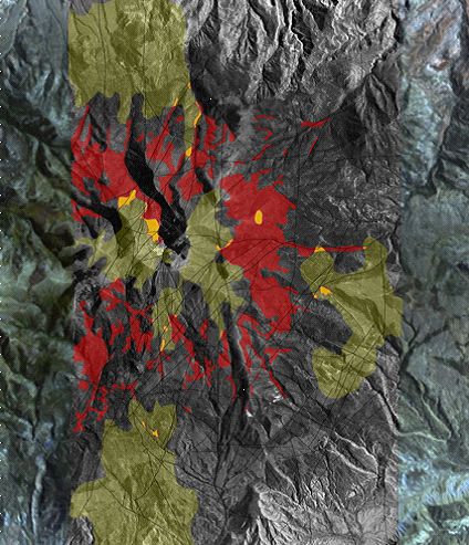
Speaking on behalf of Auracle Geospatial, David McLelland, President of Auracle’s Remote Sensing, said, “With this new relationship with DigitalGlobe, Auracle Remote Sensing looks forward to maximizing the value of spatial data for global mining and mineral exploration companies. Our data integration and fusion methodologies are a great match to DigitalGlobe’s satellite products. Auracle has developed a specialized 3-D Bare Rock Model© that combines radar and optical satellite data. Synthetic Aperture Data (SAR), one type of satellite imagery used in the process, is not affected by weather or atmospheric conditions. It penetrates vegetation, ground cover, rocks and soils to identify buried structure and alterations. Auracle is especially excited about combining our technical expertise in structural analysis with DigitalGlobe’s super-spectral WorldView-3, the most advanced commercial, high-resolution satellite imagery.”
Economic mineral and energy deposits are increasingly difficult to detect with most of the obvious deposits mined, including in the Middle East. Explorers are now focused on more remote areas that may be covered by layers of soil, rock, forest, ice, water, or agriculture.
“The ability to look through land cover, rock or soils that are laying over a mineral deposit is a great advantage in geological mapping. We can expand the search for precious and base-metal mineral occurrences into deeper areas. Auracle’s upgraded mineral maps, structural analyses and predictive models help our clients to narrow prospective targets and bring down the costs of making new, deeper discoveries. For operating mines, existing knowledge about the known deposit is applied to the Model to identify near-but yet unexplored targets,” said Auracle’s David McLelland.