SpaceWatch.Global An independent perspective on space

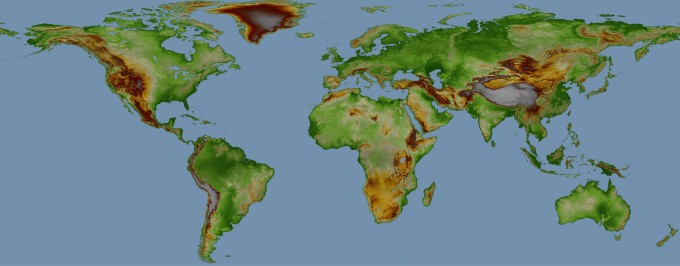
Airbus Defence and Space announced that customers can now be served with WorldDEM Digital Elevation Data for any point on Earth. Following the comprehensive global acquisition campaign and subsequent processing effort, WorldDEM data now is available for the entire World, including Antarctica and Arctic regions as well as Pacific islands. Thus WorldDEM is the first truly global elevation dataset that covers regions beyond 60° North and South without any missing areas, even in the heavily clouded Equatorial belt.
WorldDEM is a disruptive Digital Elevation Model (DEM), whose accuracy and quality surpass that of any global satellite-based elevation model available today. Setting a new standard, WorldDEM is the first global homogeneous, single-source, high-precision DEM.
“Customers across a wide range of domains have already benefitted from this game-changing dataset, and appreciate the easy global accessibility of data and the outstanding data quality” said Bernhard Brenner, Head of the Intelligence Business Cluster at Airbus Defence and Space. “The WorldDEM dataset provides an ideal visualisation tool indispensable for surveillance, reconnaissance and mission planning, and facilitates the interpretation of landscapes with exceptional detail, which is essential for military operations preparation.”
Commercial companies and institutions are also using the dataset for applications such as planning and implementation of civil engineering projects, exploration of natural resources in remote or difficult to access areas or environmental studies. Another main beneficiary of this global dataset is the aviation sector for which WorldDEM provides more accurate terrain information improving collision avoidance systems, ground proximity warning and flight management systems.
The WorldDEM product range is based on the global TanDEM-X DEM as generated by the TanDEM-X mission, which is performed jointly with the German Aerospace Center (DLR). The DLR is responsible for the scientific exploitation of all TanDEM-X data, the mission planning and execution, the control of both satellites and the processing of all satellite data. Airbus Defence and Space holds the exclusive commercial marketing rights for the data and is responsible for the adaptation of the elevation model to the needs of commercial users worldwide.
Original published at: http://spacewatchme.com/2016/10/airbus-offers-worlddem-first-global-digital-elevation-model/