SpaceWatch.Global An independent perspective on space

The successful launch on 28 April 2016 of the seventh satellite of the Indian Regional Navigation Satellite System (IRNSS) means that the Middle East region will soon have a supplementary, or even alternative, satellite navigation saystem to the American Global Positioning System (GPS), Russia’s GLONASS, and Europe’s Galileo.
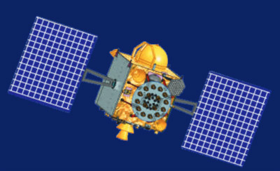
The satellite, IRNSS-1G, was launched early afternoon on 28 April from the Satish Dhawan Space Centre on Sriharikota island on the Indian coast of the Bay of Bengal. IRNSS-1G is the final satellite in the seven-satellite constellation in geostationary and geosynchronous orbits at 36,000km altitude.
IRNSS, also known as NAVIC for Navigation with Indian Constellation (Navic is also a Hindi word for sailor or navigator), will cost a total of about US$220 million for the orbital section and about US$45 million for the ground segment. The NAVIC system will provide two services: the Restricted Service reserved for Indian government and military users for now; and the Standard Positioning Service for civilian and commercial users in India and within NAVIC’s coverage area beyond, including the Middle East.
NAVIC’s coverage area ranges from much of the Middle East and East Africa through much of South- and Northeast Asia (except for Japan) and Northwest Australia. The Restricted Service signal will provide position accuracy of better than 10 meters while the Standard Positioning Service signal will provide position accuracy of better than 20 meters throughout the coverage area.
Users outside of India will be able to improve NAVIC position accuracy by using differential techniques where a network of fixed, ground-based reference stations broadcast the difference between the positions indicated by the NAVIC satellites and the known fixed positions. These stations broadcast the difference between the measured satellite pseudoranges and actual (internally computed) pseudoranges, and receiver stations may correct their pseudoranges by the same amount. The digital correction signal is then usually broadcast locally over ground-based transmitters of shorter range. With this method users can improve position accuracy from 10-20 meters to centimeters.
Once all the IRNSS satellites and the ground infrastructure have successfully completed testing, the NAVIC system will become operational, though the commercial sector has yet to produce and sell NAVIC receivers for users.
Once operational, users shall be able to exploit a combination of the US GPS system, Russia’s GLONASS, Europe’s Galileo, China’s Beidou (available in the very eastern part of the Middle East), as well as NAVIC. This range of satellite navigation providers is good news for users since they are not reliant upon any one system and can combine the services for greater position accuracy and reliability.
India developed and built NAVIC after the Indian military were denied access to the American GPS in 1999 during the Kargil War with Pakistan. NAVIC therefore provides a measure of strategic autonomy for India as well as providing a supplementary satellite navigation system for civilian and commercial users.
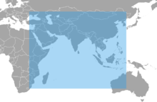
The Middle Eastern countries that will eventually be able to use NAVIC are as follows: Bahrain, Eastern Egypt, Iraq, Iran, Israel, Jordan, Kuwait, Lebanon, Oman, Qatar, Saudi Arabia, Syria, most of Turkey, United Arab Emirates, and Yemen.